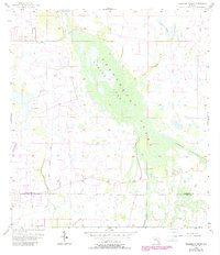
1956 Map of Telegraph Swamp
USGS Topo · Published 1988About this map
Babcock Ranch anchors the northern reaches of this landscape where the boundaries of Charlotte and Lee counties meet. The area is defined by an extensive hydrological network, most notably the wide expanse of Telegraph Swamp and the waters of Currys Lake. These natural drainages are supplemented by man-made alterations like the Big Island Canal, which reflects mid-century efforts to manage the low-lying Florida terrain for ranching and agriculture.
Find a feature on this map
13 named features on this map. Tap any name to fly to it.
Don’t see what you’re looking for? This feature index may not catch every label — zoom into the map to look around manually.
Map Details
Editions of this 1956 Telegraph Swamp Map
3 editions found
Other maps of this area

1956 · Telegraph Swamp
USGS Topo · 1:24,000

1956 · Telegraph Swamp NE
USGS Topo · 1:24,000

1956 · Telegraph Swamp NW
USGS Topo · 1:24,000

1956 · Bermont
USGS Topo · 1:24,000

1956 · West Palm Beach
USGS Topo · 1:250,000

1957 · West Palm Beach
USGS Topo · 1:250,000

1957 · Tuckers Corner
USGS Topo · 1:24,000

1957 · Telegraph Swamp SE
USGS Topo · 1:24,000

1958 · West Palm Beach
USGS Topo · 1:250,000

1958 · Olga
USGS Topo · 1:24,000