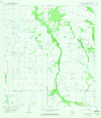
1957 Map of Telegraph Swamp SE
USGS Topo · Published 1972About this map
Jacks Branch and Cypress Cr define the low-lying wetland landscape across this 1957 survey where the borders of Charlotte, Glades, Lee, and Hendry counties meet. This interior region of Southwest Florida appears largely uninhabited, characterized by extensive drainage patterns and scattered water features such as the Flowing Well in the western reaches. The few signs of human establishment are found primarily at the edges of the survey, where small pioneer burial grounds like Muse Cem and Fort Denaud Cem provide critical touchpoints for genealogists researching family ties in this transition zone between the Everglades and the Caloosahatchee basin. The lack of formal road networks or dense settlement at this time highlights the area's rural character during the mid-20th century before later development altered much of the regional hydrology.
Find a feature on this map
9 named features on this map. Tap any name to fly to it.
Don’t see what you’re looking for? This feature index may not catch every label — zoom into the map to look around manually.
Map Details
Editions of this 1957 Telegraph Swamp SE Map
3 editions found
Other maps of this area

1956 · Telegraph Swamp
USGS Topo · 1:24,000

1956 · Telegraph Swamp NE
USGS Topo · 1:24,000

1956 · Telegraph Swamp NW
USGS Topo · 1:24,000

1956 · West Palm Beach
USGS Topo · 1:250,000

1957 · West Palm Beach
USGS Topo · 1:250,000

1957 · Telegraph Swamp SE
USGS Topo · 1:24,000

1958 · West Palm Beach
USGS Topo · 1:250,000

1958 · La Belle NW
USGS Topo · 1:24,000

1958 · Olga
USGS Topo · 1:24,000

1958 · Alva
USGS Topo · 1:24,000