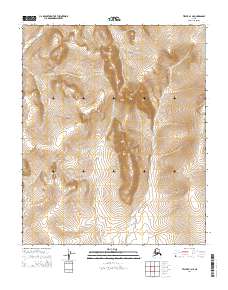
2014 Map of Teller B-1 NE
USGS Topo · Published 2014About this map
The headwaters of several prominent drainage systems define the high country of the Seward Peninsula in this 2014 study by the U.S. Geological Survey. In the northwest, the map tracks the upper reaches of Igloo Cr, while Louisville Cr cuts a significant east-west path across the northern interior. This terrain is marked by a complex network of seasonal and perennial streams that have carved deep into the landscape over millennia. Central to this hydrology is Johnston Cr, which flows south toward the coastal lowlands, and Coco Cr, which drains the eastern portion of the quadrangle. These watercourses were historically vital for prospecting and seasonal transit in the region north of Nome, serving as natural landmarks for movement through the treeless interior. The map clearly delineates the t1n r32w and t1s r31w survey boundaries, providing a precise spatial framework for land management and mineral exploration in this remote portion of Alaska.
Find a feature on this map
10 named features on this map. Tap any name to fly to it.
Don’t see what you’re looking for? This feature index may not catch every label — zoom into the map to look around manually.
Map Details
Editions of this 2014 Teller B-1 NE Map
This is the sole edition of this map. No revisions or reprints were ever made.
Other maps of this area

1950 · Bendeleben B-6
USGS Topo · 1:63,360

1950 · Bendeleben C-6
USGS Topo · 1:63,360

1950 · Teller
USGS Topo · 1:250,000

1950 · Bendeleben
USGS Topo · 1:250,000

1950 · Teller B-1
USGS Topo · 1:63,360
1950 · Teller C-1
USGS Topo · 1:63,360

1951 · Bendeleben
USGS Topo · 1:250,000

1951 · Teller
USGS Topo · 1:250,000

1957 · Teller
USGS Topo · 1:250,000

1958 · Teller
USGS Topo · 1:250,000