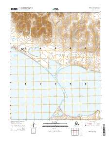
2014 Map of Teller B-3 SW
USGS Topo · Published 2014About this map
Red Mountain dominates the northern interior of this Seward Peninsula landscape, where high tundra slopes descend toward the coastal waters of Brevig Lagoon and Port Clarence. The settlement of Teller occupies a precarious spit of land at the mouth of the lagoon, serving as a critical jumping-off point for travel across the region. This 2014 survey captures the modern infrastructure connecting these remote coastal communities, including the Brevig Mission Airport and the primary overland artery, the Nome-Teller Highway / Bob Blodgett Highway. Numerous drainages such as Shelman Cr and Mountain Cr carve through the foothills, while the historic Teller-Cape Prince of Wales Trail marks a long-standing route of movement along the northern shore, tracing the intersection of sea and land near Fourmile Point.
Find a feature on this map
26 named features on this map. Tap any name to fly to it.
Don’t see what you’re looking for? This feature index may not catch every label — zoom into the map to look around manually.
Map Details
Editions of this 2014 Teller B-3 SW Map
This is the sole edition of this map. No revisions or reprints were ever made.
Other maps of this area

1950 · Teller
USGS Topo · 1:250,000

1950 · Teller B-4
USGS Topo · 1:63,360

1950 · Teller A-3
USGS Topo · 1:63,360

1950 · Teller A-4
USGS Topo · 1:63,360

1950 · Teller B-3
USGS Topo · 1:63,360

1951 · Teller
USGS Topo · 1:250,000

1957 · Teller
USGS Topo · 1:250,000

1958 · Teller
USGS Topo · 1:250,000
2014 · Teller B-3 SE
USGS Topo · 1:25,000
2014 · Teller B-4 NE
USGS Topo · 1:25,000