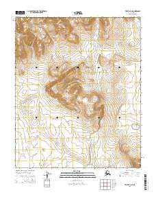
2014 Map of Teller B-4 NE
USGS Topo · Published 2014About this map
Black Mountain anchors the northern high ground of this landscape, overlooking a series of watercourses that drain toward the south and east. The drainage pattern is defined by the California River, which winds through the central and eastern sections, joined by tributaries such as Killestok Cr and Fish Cr. The terrain is marked by the distinct absence of roads or permanent settlements, reflecting the remote character of this region near Nome. The Agiupuk River enters at the northeastern corner, indicating the broader hydraulic connection of this interior area. These water systems, including Skull Cr and Thompson Cr, represent the primary landmarks for navigation in a territory defined by its natural elevation and seasonal flow rather than human infrastructure.
Find a feature on this map
12 named features on this map. Tap any name to fly to it.
Don’t see what you’re looking for? This feature index may not catch every label — zoom into the map to look around manually.
Map Details
Editions of this 2014 Teller B-4 NE Map
This is the sole edition of this map. No revisions or reprints were ever made.
Other maps of this area

1950 · Teller
USGS Topo · 1:250,000

1950 · Teller B-4
USGS Topo · 1:63,360

1950 · Teller C-3
USGS Topo · 1:63,360

1950 · Teller C-4
USGS Topo · 1:63,360

1950 · Teller B-3
USGS Topo · 1:63,360

1951 · Teller
USGS Topo · 1:250,000

1957 · Teller
USGS Topo · 1:250,000

1958 · Teller
USGS Topo · 1:250,000
2014 · Teller C-4 SW
USGS Topo · 1:25,000
2014 · Teller C-4 SE
USGS Topo · 1:25,000