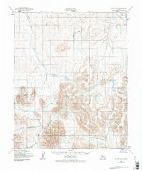
1950 Map of Teller C-4
USGS Topo · Published 1977About this map
Continental Divide crests across the Seward Peninsula in this 1950s-era topographic study, marking the primary watershed separation in this portion of the Nome region. The landscape is defined by a dense network of watercourses, where the Pinguk River and its various tributaries, such as Upkuarok Creek, drain the high ground toward the coast. The mapping, based on aerial photography from the late 1940s, reveals a terrain entirely devoid of established roads or trails during this period. Local drainage patterns are exceptionally detailed, showing the courses of the Nuluk River, Don River, and California River as they carve through the inland elevations. Minor branches like Deer Br and Willow Br feed into the larger river systems, illustrating the complex hydrology of the Alaskan interior before modern development. This document serves as a baseline for the remote geography of the peninsula, tracing the natural flow of water before any significant human infrastructure altered the landscape.
Find a feature on this map
11 named features on this map. Tap any name to fly to it.
Don’t see what you’re looking for? This feature index may not catch every label — zoom into the map to look around manually.
Map Details
Editions of this 1950 Teller C-4 Map
2 editions found
Other maps of this area

1950 · Teller
USGS Topo · 1:250,000

1950 · Teller B-4
USGS Topo · 1:63,360

1950 · Teller C-3
USGS Topo · 1:63,360

1950 · Teller D-3
USGS Topo · 1:63,360

1950 · Teller D-5
USGS Topo · 1:63,360

1950 · Teller C-4
USGS Topo · 1:63,360

1950 · Teller B-3
USGS Topo · 1:63,360
1950 · Teller B-5
USGS Topo · 1:63,360
1950 · Teller D-4
USGS Topo · 1:63,360

1950 · Teller C-5
USGS Topo · 1:63,360