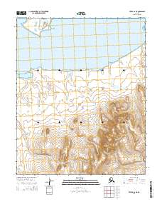
2014 Map of Teller C-6 NE
USGS Topo · Published 2014About this map
Potato Mountain rises as the dominant landmark in this coastal region of the Seward Peninsula, overlooking a landscape defined by the expansive Lopp Lagoon to the north. The terrain transitions from the low-lying shoreline of the lagoon into a series of drainage basins carved by seasonal watercourses. These drainages, including Oakland Cr, Dry Cr, and Red Fox Cr, flow northward from the higher elevations of the mountain range toward the coast. In the southern portion of the map, the landscape shifts toward more interior drainage patterns, where Sutter Cr, Lynx Cr, and Nonna Cr navigate the contours of the tundra. The mapping of these specific tributaries and the isolation of the mountain peak provides a clear view of the natural hydrology that has dictated movement and land use in this remote area.
Find a feature on this map
14 named features on this map. Tap any name to fly to it.
Don’t see what you’re looking for? This feature index may not catch every label — zoom into the map to look around manually.
Map Details
Editions of this 2014 Teller C-6 NE Map
This is the sole edition of this map. No revisions or reprints were ever made.
Other maps of this area

1950 · Teller
USGS Topo · 1:250,000

1950 · Teller C-6
USGS Topo · 1:63,360

1950 · Teller D-5
USGS Topo · 1:63,360
1950 · Teller D-6
USGS Topo · 1:63,360

1950 · Teller C-5
USGS Topo · 1:63,360

1951 · Teller
USGS Topo · 1:250,000

1957 · Teller
USGS Topo · 1:250,000

1958 · Teller
USGS Topo · 1:250,000
2014 · Teller C-5 SW
USGS Topo · 1:25,000
2014 · Teller D-5 SW
USGS Topo · 1:25,000