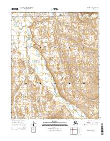
2014 Map of Teller D-4 SE
USGS Topo · Published 2014About this map
The Bering Land Bridge National Preserve occupies the northern reaches of this coastal Alaskan landscape, where the tundra meets the Seward Peninsula's complex drainage systems. Two primary watercourses, the Nuluk River and the Kugrupaga River, dominate the hydrology of the area, winding through low-lying terrain characterized by subtle elevation changes and numerous smaller tributaries. This 2014 survey documents the remote backcountry north of Nome, emphasizing the natural boundary lines of township and range subdivisions like t6n r38w and t5n r37w. The network of seasonal streams, including Deep Cr and Cooper Cr, illustrates the intricate flow patterns essential to this subarctic environment, providing a technical record of the land's physical geography before modern climatic shifts further alter the permafrost-dependent terrain.
Find a feature on this map
11 named features on this map. Tap any name to fly to it.
Don’t see what you’re looking for? This feature index may not catch every label — zoom into the map to look around manually.
Map Details
Editions of this 2014 Teller D-4 SE Map
This is the sole edition of this map. No revisions or reprints were ever made.
Other maps of this area

1950 · Teller
USGS Topo · 1:250,000

1950 · Teller C-3
USGS Topo · 1:63,360

1950 · Teller D-3
USGS Topo · 1:63,360

1950 · Teller C-4
USGS Topo · 1:63,360
1950 · Teller D-4
USGS Topo · 1:63,360

1951 · Teller
USGS Topo · 1:250,000

1957 · Teller
USGS Topo · 1:250,000

1958 · Teller
USGS Topo · 1:250,000
2014 · Teller D-3 SW
USGS Topo · 1:25,000
2014 · Teller D-4 NW
USGS Topo · 1:25,000