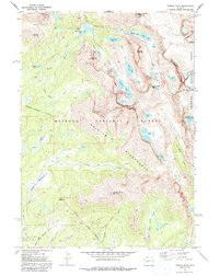
1969 Map of Temple Peak
USGS Topo · Published 1992About this map
The Continental Divide defines the eastern boundary of this high-altitude landscape, separating the Bridger National Forest from the Shoshone National Forest. This 1960s survey documents a world of alpine water and granite peaks, centered on the glacial basin of Big Sandy Lake and the towering heights of Temple Peak and Wind River Peak. The drainage patterns are clearly defined, showing how North Temple Creek and South Temple Creek feed into the Big Sandy River, while the Dutch Joe Creek and Squaw Creek networks carve through the southern portion of the quadrangle. Significant markers for backcountry navigation include the Schiestler Peak landmark and the expansive Sedgewick Meadows. This map preserves the primitive state of the Bridger Wilderness before modern recreation intensified, showing only an established Pack Trail system as the primary means of traversing the high passes and lake chains like Black Joe Lake and Deep Lake.
Find a feature on this map
41 named features on this map. Tap any name to fly to it.
Don’t see what you’re looking for? This feature index may not catch every label — zoom into the map to look around manually.
Map Details
Editions of this 1969 Temple Peak Map
2 editions found
Other maps of this area

1937 · Moccasin Lake
USGS Topo · 1:48,000

1938 · Mt Bonneville
USGS Topo · 1:62,500

1941 · Mt Bonneville
USGS Topo · 1:62,500

1942 · Mt Bonneville
USGS Topo · 1:62,500

1943 · Moccasin Lake
USGS Topo · 1:62,500

1953 · Sweetwater Gap
USGS Topo · 1:24,000

1955 · Lander
USGS Topo · 1:250,000

1958 · Lander
USGS Topo · 1:250,000

1961 · Lander
USGS Topo · 1:250,000

1969 · Jensen Meadows
USGS Topo · 1:24,000