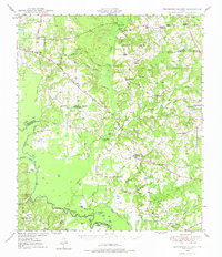
1949 Map of Tennessee Colony
USGS Topo · Published 1975About this map
Tennessee Colony and the surrounding Anderson County bottomlands are defined by the winding course of the Trinity River, which forms the western boundary of this 1940s landscape. The area is a mosaic of agriculture and early industrial development, anchored by the Blackfoot Oil Field and an extensive underground pipe line network. Rural life in this era centered on tightly-knit communities identified by their local institutions, such as Cayuga Sch, WBS Sch, and the New Bethel Ch.
Find a feature on this map
66 named features on this map. Tap any name to fly to it.
Don’t see what you’re looking for? This feature index may not catch every label — zoom into the map to look around manually.
Map Details
Editions of this 1949 Tennessee Colony Map
2 editions found
Other maps of this area

1919 · Fairfield
USGS Topo · 1:62,500

1949 · Palestine
USGS Topo · 1:62,500

1949 · Frankston
USGS Topo · 1:62,500

1949 · Athens
USGS Topo · 1:62,500

1949 · Tennessee Colony
USGS Topo · 1:62,500

1950 · Athens
USGS Topo · 1:62,500

1950 · Palestine
USGS Topo · 1:62,500

1950 · Frankston
USGS Topo · 1:62,500

1950 · Tennessee Colony
USGS Topo · 1:62,500

1951 · Elkhart
USGS Topo · 1:62,500