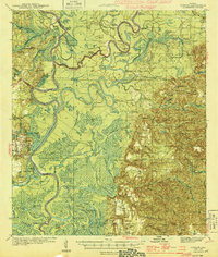
1944 Map of Tensaw
USGS Topo · Published 1944About this map
The complex confluence of the Tombigbee River and the Alabama River dominates this mid-century landscape, revealing a riverine economy built on numerous landings and remote plantations. Local maritime life is evidenced by Davis Ldg, Betts Lower Ldg, and Boathouse Ldg, which served as vital transit points for timber and cotton before the expansion of modern highways. Historic fortifications, including Old Ft Stoddard and Ft Mimms Ch, highlight the area's strategic importance in early Alabama history.
Find a feature on this map
105 named features on this map. Tap any name to fly to it.
Don’t see what you’re looking for? This feature index may not catch every label — zoom into the map to look around manually.
Map Details
Editions of this 1944 Tensaw Map
3 editions found


Other maps of this area

1941 · Bay Minette
USGS Topo · 1:62,500

1941 · Creola
USGS Topo · 1:62,500

1942 · Perdido
USGS Topo · 1:62,500

1942 · Dyas
USGS Topo · 1:62,500

1943 · Creola
USGS Topo · 1:62,500

1943 · Bay Minette
USGS Topo · 1:62,500

1943 · Choctaw Bluff
USGS Topo · 1:62,500

1943 · Tensaw
USGS Topo · 1:62,500

1943 · Citronelle
USGS Topo · 1:62,500

1943 · McIntosh
USGS Topo · 1:62,500