
1944 Map of Tensaw
USGS Topo · Published 1951About this map
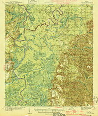
Alabama River bottomlands dominate this mid-century landscape, revealing a complex network of landings and plantations critical to the river-based economy of the 1940s. The map details a transition from the swampy wetlands of Robinson Island and Aikin Island to the higher ground of Montgomery Hill and the settlement at Stockton. Genealogists will find significant value in the distribution of family-named landmarks and rural infrastructure, including Tate Cem, Lancaster Cem, and Richardson Cem.
Find a feature on this map
125 named features on this map. Tap any name to fly to it.
Don’t see what you’re looking for? This feature index may not catch every label — zoom into the map to look around manually.
Map Details
Editions of this 1944 Tensaw Map
3 editions found

Other maps of this area

1941 · Bay Minette
USGS Topo · 1:62,500

1941 · Creola
USGS Topo · 1:62,500

1942 · Perdido
USGS Topo · 1:62,500

1942 · Dyas
USGS Topo · 1:62,500

1943 · Creola
USGS Topo · 1:62,500

1943 · Bay Minette
USGS Topo · 1:62,500

1943 · Choctaw Bluff
USGS Topo · 1:62,500

1943 · Tensaw
USGS Topo · 1:62,500

1943 · Citronelle
USGS Topo · 1:62,500

1943 · McIntosh
USGS Topo · 1:62,500