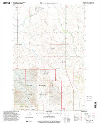
1997 Map of Tepee Buttes
USGS Topo · Published 2001About this map
Tepee Buttes and the high plains of McKenzie County dominate this 1990s landscape, where the public lands of the Little Missouri National Grassland meet the protected wilderness of the Badlands. The map reveals a remote ranching and conservation corridor, specifically where the Theodore Roosevelt National Park (North Unit) and the Theodore Roosevelt Wilderness establish a footprint in the southern portion of the quadrangle.
Find a feature on this map
18 named features on this map. Tap any name to fly to it.
Don’t see what you’re looking for? This feature index may not catch every label — zoom into the map to look around manually.
Map Details
Editions of this 1997 Tepee Buttes Map
This is the sole edition of this map. No revisions or reprints were ever made.
Other maps of this area

1953 · Watford City
USGS Topo · 1:250,000

1957 · Watford City
USGS Topo · 1:250,000

1958 · Long X Divide
USGS Topo · 1:24,000

1958 · Sperati Point
USGS Topo · 1:24,000

1958 · Lone Butte
USGS Topo · 1:24,000

1958 · Stocke Butte
USGS Topo · 1:24,000

1958 · Tepee Buttes
USGS Topo · 1:24,000

1959 · Lone Butte NW
USGS Topo · 1:24,000

1967 · Watford City
USGS Topo · 1:250,000

1978 · Arnegard
USGS Topo · 1:24,000