
1958 Map of Tepee Creek
USGS Topo · Published 1963About this map
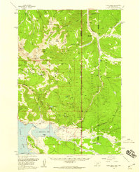
Hebgen Lake dominates the southwestern corner of this late-1950s survey, showing the complex shoreline of the Grayling Arm just before the 1959 Hebgen Lake earthquake permanently altered the local geography. The map captures a transition point where the Gallatin National Forest meets the western edge of Yellowstone National Park, marked by the Montana Wyoming state line. Backcountry infrastructure of the era is well-documented, from the Cabin Creek Ranger Sta and Patrol Cabin to the seasonal Bacon Rind Creek Road Camp. These outposts, along with the Parade Rest Ranch, supported the region's management and early tourism before more modern development took hold. The landscape is defined by high-elevation drainage systems like Tepee Creek and Duck Creek, which flow toward the reservoir through a network of named ridges and peaks such as Monument Mountain and Ernest Miller Ridge.
Find a feature on this map
60 named features on this map. Tap any name to fly to it.
Don’t see what you’re looking for? This feature index may not catch every label — zoom into the map to look around manually.
Map Details
Editions of this 1958 Tepee Creek Map
2 editions found
Other maps of this area

1885 · Gallatin
USGS Topo · 1:125,000

1885 · Gallatin
USGS Topo · 1:125,000

1888 · Three Forks
USGS Topo · 1:250,000

1891 · Livingston
USGS Topo · 1:250,000

1893 · Livingston
USGS Topo · 1:250,000

1894 · Three Forks
USGS Topo · 1:250,000

1895 · Three Forks
USGS Topo · 1:250,000

1901 · Gallatin
USGS Topo · 1:125,000
1908 · Gallatin
USGS Topo · 1:125,000
1911 · Gallatin
USGS Topo · 1:125,000