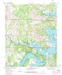
1970 Map of Terlton
USGS Topo · Published 1983About this map
Keystone Lake dominates the landscape where the Cimarron River meets several smaller tributaries, including Cowskin Creek and House Creek. The map documents a significant intersection of history and modern development, most notably marked by the Old Indian Territory Oklahoma Territory Boundary that runs east-to-west across the center. Transportation networks define the area's movement, from the heavy tracks of the Burlington Northern and an older Railroad Grade to the path of the Cimarron Turnpike.
Find a feature on this map
28 named features on this map. Tap any name to fly to it.
Don’t see what you’re looking for? This feature index may not catch every label — zoom into the map to look around manually.
Map Details
Editions of this 1970 Terlton Map
2 editions found
Other maps of this area

1912 · Hominy
USGS Topo · 1:125,000

1915 · Hominy
USGS Topo · 1:125,000

1915 · Hominy
USGS Topo · 1:62,500

1929 · Yale
USGS Topo · 1:62,500

1929 · Skedee
USGS Topo · 1:62,500

1931 · Skedee
USGS Topo · 1:62,500

1932 · Yale
USGS Topo · 1:62,500

1955 · Enid
USGS Topo · 1:250,000

1958 · Enid
USGS Topo · 1:250,000

1958 · Keystone Dam
USGS Topo · 1:24,000