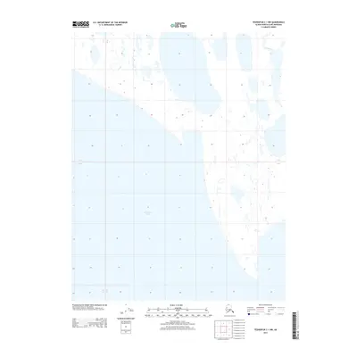
2013 Map of Teshekpuk C-1 NW
USGS Topo · Published 2013About this map
Teshekpuk Lake dominates the southern portion of this Arctic coastal landscape on the North Slope. This 2013 survey illustrates the complex, low-lying hydrology of the region, where the massive freshwater body meets a network of smaller ponds and wetlands. The intricate shoreline of the lake and the path of the Smith River in the northeast corner highlight the delicate interplay between water and tundra in a region largely defined by permafrost and seasonal changes. While the map is devoid of human settlements or infrastructure, it serves as a precise record of the shoreline and drainage patterns as they existed in the early 21st century.
Find a feature on this map
2 named features on this map. Tap any name to fly to it.
Don’t see what you’re looking for? This feature index may not catch every label — zoom into the map to look around manually.
Map Details
Editions of this 2013 Teshekpuk C-1 NW Map
This is the sole edition of this map. No revisions or reprints were ever made.
Other maps of this area

1951 · Teshekpuk
USGS Topo · 1:250,000

1955 · Teshekpuk
USGS Topo · 1:250,000

1955 · Teshekpuk D-1
USGS Topo · 1:63,360
1955 · Teshekpuk C-2
USGS Topo · 1:63,360
1955 · Teshekpuk C-1
USGS Topo · 1:63,360
1955 · Teshekpuk D-2
USGS Topo · 1:63,360
1962 · Teshekpuk C-2
USGS Topo · 1:50,000

1964 · Teshekpuk
USGS Topo · 1:250,000
2013 · Teshekpuk C-2 NE
USGS Topo · 1:25,000
2013 · Teshekpuk C-1 SE
USGS Topo · 1:25,000