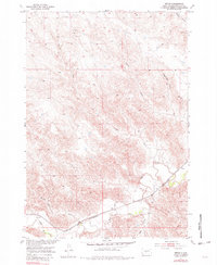
1953 Map of Teton
USGS Topo · Published 1982About this map
The Chicago and North Western railroad corridor defines the development of this South Dakota landscape, following the southern banks of the Bad River as it winds through Stanley County. The small settlement of Teton sits as a vital point along these tracks, serving as a focal point for the surrounding ranching and agricultural country. The terrain is deeply incised by a network of drainages including Stranger Creek, Ash Creek, and the curiously named Broken Neck Creek, all of which feed into the primary river valley. These watercourses have carved significant features into the plains, most notably Niggeredge Canyon in the northeast. This 1953 survey, photoinspected in the mid-1970s, captures a moment when the regional economy was tied closely to the rail line and the reliable water of the river bottomlands before major modern infrastructure changes.
Find a feature on this map
11 named features on this map. Tap any name to fly to it.
Don’t see what you’re looking for? This feature index may not catch every label — zoom into the map to look around manually.
Map Details
Editions of this 1953 Teton Map
2 editions found
Other maps of this area

1924 · Pierre
USGS Topo · 1:62,500

1937 · Oahe
USGS Topo · 1:62,500

1953 · Teton
USGS Topo · 1:24,000

1953 · Oahe SW
USGS Topo · 1:24,000

1953 · Pierre SW
USGS Topo · 1:24,000

1953 · Wendte
USGS Topo · 1:24,000

1953 · Wendte NE
USGS Topo · 1:24,000

1953 · Pierre 3 NW
USGS Topo · 1:24,000

1954 · Pierre
USGS Topo · 1:250,000

1958 · Pierre
USGS Topo · 1:250,000