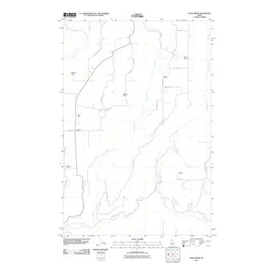
2011 Map of Texas Ridge
USGS Topo · Published 2011About this map
Texas Ridge and its neighboring highland formations dominate this portion of Nez Perce County, where the high plateau is deeply incised by the Potlatch River and its various tributaries. This 2011 survey illustrates a landscape defined by its ridges—including Big Bear Ridge and Huffman Ridge—and the winding roads that follow the high ground. The distribution of small rural burial grounds, such as Elwood Cemetery and Wild Rose Cemetery, suggests a long-standing community tied to the local terrain. The drainage systems of Big Bear Creek and Cedar Creek show the complex watershed patterns that feed into the larger river system, while local routes like Texas Ridge Rd and Elwood School Rd provide evidence of the area's historical settlement structure and development over time.
Find a feature on this map
31 named features on this map. Tap any name to fly to it.
Don’t see what you’re looking for? This feature index may not catch every label — zoom into the map to look around manually.
Map Details
Editions of this 2011 Texas Ridge Map
This is the sole edition of this map. No revisions or reprints were ever made.
Other maps of this area

1955 · Pullman
USGS Topo · 1:250,000

1958 · Pullman
USGS Topo · 1:250,000

1961 · Deary
USGS Topo · 1:62,500

1961 · Kendrick
USGS Topo · 1:62,500

1961 · Ahsahka
USGS Topo · 1:62,500

1961 · Bovill
USGS Topo · 1:62,500

1981 · Potlatch
USGS Topo · 1:100,000
1990 · Juliaetta
USGS Topo · 1:24,000
1990 · Stanford
USGS Topo · 1:24,000
1990 · Lenore
USGS Topo · 1:24,000