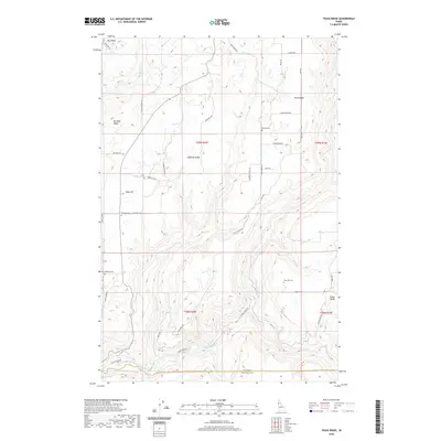
2020 Map of Texas Ridge
USGS Topo · Published 2020About this map
Texas Ridge dominates this northern Idaho landscape, where high plateaus are carved by the winding course of the Potlatch River. The terrain is defined by a series of prominent elevations including Huffman Ridge, Big Bear Ridge, and Cedar Ridge, each separated by drainages like Big Bear Cr and Pine Cr. This 2020 survey illustrates a rural upland environment largely structured by long-established section lines and ridge-top roads such as Big Bear Ridge Rd and Texas Ridge Rd. For genealogists and local historians, the map is particularly useful for identifying small community anchors, including the Bethany Cem, Elwood Cem, Wild Rose Cem, and Gold Hill Cem. The boundary between Latah Co and Nez Perce Co runs through the southern portion of the quadrangle, marking the transition between these two jurisdictions amidst the rugged breaks of the river canyon.
Find a feature on this map
39 named features on this map. Tap any name to fly to it.
Don’t see what you’re looking for? This feature index may not catch every label — zoom into the map to look around manually.
Map Details
Editions of this 2020 Texas Ridge Map
This is the sole edition of this map. No revisions or reprints were ever made.
Other maps of this area

1955 · Pullman
USGS Topo · 1:250,000

1958 · Pullman
USGS Topo · 1:250,000

1961 · Deary
USGS Topo · 1:62,500

1961 · Kendrick
USGS Topo · 1:62,500

1961 · Ahsahka
USGS Topo · 1:62,500

1961 · Bovill
USGS Topo · 1:62,500

1981 · Potlatch
USGS Topo · 1:100,000
1990 · Juliaetta
USGS Topo · 1:24,000
1990 · Stanford
USGS Topo · 1:24,000
1990 · Lenore
USGS Topo · 1:24,000