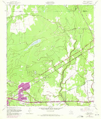
1957 Map of Texla
USGS Topo · Published 1971About this map
The settlement of Vidor emerges as a growing community in this mid-century survey, with residential developments like Maple Crest Acres and Lakewood beginning to fill the landscape. This area of Orange County is a complex network of industrial activity and historical transit routes, anchored by the namesake village of Texla in the north and Doty further south. The map documents a significant era of petroleum and timber transport, featuring an active rail corridor served by the Kansas City Southern and Missouri Pacific lines, alongside an abandoned rail spur and numerous Oil Wells.
Find a feature on this map
29 named features on this map. Tap any name to fly to it.
Don’t see what you’re looking for? This feature index may not catch every label — zoom into the map to look around manually.
Map Details
Editions of this 1957 Texla Map
3 editions found
Other maps of this area

1926 · Terry
USGS Topo · 1:24,000

1926 · Lakeview
USGS Topo · 1:24,000

1926 · Vidor
USGS Topo · 1:24,000

1926 · Texla
USGS Topo · 1:24,000

1926 · Mauriceville
USGS Topo · 1:24,000

1932 · Beaumont
USGS Topo · 1:62,500

1943 · Orangefield
USGS Topo · 1:24,000

1943 · Mauriceville
USGS Topo · 1:24,000

1943 · Terry
USGS Topo · 1:24,000

1943 · Texla
USGS Topo · 1:24,000