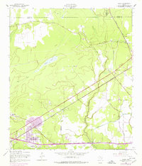
1957 Map of Texla
USGS Topo · Published 1979About this map
Cow Bayou and the lowlands of Southeast Texas define this landscape as it appeared during the late 1950s, with later urban expansions into the 1970s highlighted in purple. The community of Vidor serves as the primary population center, showing residential developments like Maple Crest Acres and Lakewood expanding toward the southern edge of the quadrangle. Transport and industry are central to the area's layout, with the Kansas City Southern and Missouri Pacific railroads cutting through the timber and marshlands.
Find a feature on this map
24 named features on this map. Tap any name to fly to it.
Don’t see what you’re looking for? This feature index may not catch every label — zoom into the map to look around manually.
Map Details
Editions of this 1957 Texla Map
3 editions found
Other maps of this area

1926 · Terry
USGS Topo · 1:24,000

1926 · Lakeview
USGS Topo · 1:24,000

1926 · Vidor
USGS Topo · 1:24,000

1926 · Texla
USGS Topo · 1:24,000

1926 · Mauriceville
USGS Topo · 1:24,000

1932 · Beaumont
USGS Topo · 1:62,500

1943 · Orangefield
USGS Topo · 1:24,000

1943 · Mauriceville
USGS Topo · 1:24,000

1943 · Terry
USGS Topo · 1:24,000

1943 · Texla
USGS Topo · 1:24,000