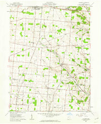
1961 Map of Thackery
USGS Topo · Published 1962About this map
Saint Paris anchors the northern edge of this west-central Ohio landscape, where the Pennsylvania railroad line cuts through a territory defined by small settlements and established family farmsteads. The agricultural character of the region is punctuated by numerous rural burial grounds such as Myrtle Tree Cem and Jenks-Kite Cem, alongside local landmarks like the Graham Local High Sch.
Find a feature on this map
67 named features on this map. Tap any name to fly to it.
Don’t see what you’re looking for? This feature index may not catch every label — zoom into the map to look around manually.
Map Details
Editions of this 1961 Thackery Map
This is the sole edition of this map. No revisions or reprints were ever made.
Other maps of this area

1904 · Springfield
USGS Topo · 1:62,500

1904 · Dayton
USGS Topo · 1:62,500

1906 · Dayton
USGS Topo · 1:62,500

1906 · Springfield
USGS Topo · 1:62,500

1914 · Troy
USGS Topo · 1:62,500

1914 · St. Paris
USGS Topo · 1:62,500

1916 · St. Paris
USGS Topo · 1:62,500

1944 · St. Paris
USGS Topo · 1:62,500

1944 · Troy
USGS Topo · 1:62,500

1947 · Columbus
USGS Topo · 1:250,000