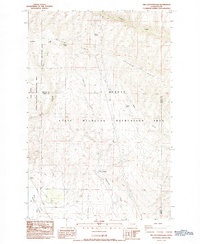
1984 Map of The Cottonwoods
USGS Topo · Published 1985About this map
Umtanum Ridge dominates this mid-1980s landscape, where the high desert terrain transitions between Kittitas and Yakima counties. The area is defined by the expansive L T Murray State Wildlife Recreation Area, a region primarily dedicated to habitat conservation and seasonal water management. Traceable landmarks such as Barnes Cabin and The Cottonwoods indicate early human presence in an environment focused on drainage systems like Umtanum Creek and Cottonwood Creek.
Find a feature on this map
18 named features on this map. Tap any name to fly to it.
Don’t see what you’re looking for? This feature index may not catch every label — zoom into the map to look around manually.
Map Details
Editions of this 1984 The Cottonwoods Map
This is the sole edition of this map. No revisions or reprints were ever made.
Other maps of this area

1899 · Ellensburg
USGS Topo · 1:125,000

1901 · Ellensburg
USGS Topo · 1:125,000

1936 · Yakima East
USGS Topo · 1:48,000

1938 · Badger Pocket
USGS Topo · 1:48,000

1941 · Yakima East
USGS Topo · 1:62,500

1943 · Badger Pocket
USGS Topo · 1:62,500

1950 · Yakima
USGS Topo · 1:250,000

1953 · Pomona
USGS Topo · 1:24,000

1953 · Kittitas
USGS Topo · 1:24,000
1953 · Wymer
USGS Topo · 1:24,000