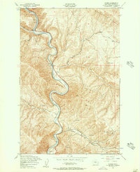
1953 Map of Wymer
USGS Topo · Published 1957About this map
The Yakima River carves a deep, winding canyon through the high ridges of Kittitas County, dictating the development of the river-and-rail corridor during the mid-20th century. Along the narrow riverbanks, small settlements such as Umtanum, Wymer, and Roza follow the path of the Northern Pacific railroad, which provided the primary means of transit through this steep terrain. The landscape is defined by massive formations like Manastash Ridge and Umtanum Ridge, separated by deep cuts like McPherson Canyon. Evidence of early resource extraction is visible at an Abandoned Mine west of the river, while the local ranching or survey history is reflected in specific water sources such as Tendollar Spring and Windy Spring. Infrastructure of the era is remarkably specific, including a Gaging Sta for monitoring river flow and an Aerial Cable crossing the river near Umtanum.
Find a feature on this map
23 named features on this map. Tap any name to fly to it.
Don’t see what you’re looking for? This feature index may not catch every label — zoom into the map to look around manually.
Map Details
Editions of this 1953 Wymer Map
2 editions found
Other maps of this area

1899 · Ellensburg
USGS Topo · 1:125,000

1901 · Ellensburg
USGS Topo · 1:125,000

1936 · Yakima East
USGS Topo · 1:48,000

1938 · Badger Pocket
USGS Topo · 1:48,000

1941 · Yakima East
USGS Topo · 1:62,500

1943 · Badger Pocket
USGS Topo · 1:62,500

1950 · Yakima
USGS Topo · 1:250,000

1953 · Pomona
USGS Topo · 1:24,000
1953 · Badger Gap
USGS Topo · 1:24,000
1953 · East Kittitas
USGS Topo · 1:24,000