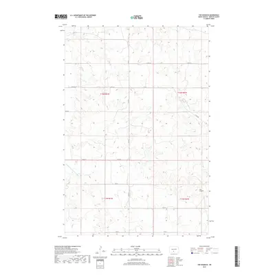
2018 Map of The Hogback
USGS Topo · Published 2018About this map
The Hogback rises as the central topographic landmark in this section of Morton County, where the high prairie begins to drain toward the Missouri River basin. The landscape is defined by the winding paths of the Br Cantapeta Cr and its tributary, the Northwest Br Cantapeta Cr, which carve through the undulating terrain in the eastern half of the survey. To the west, the headwaters of the Southeast Br Little Heart River mark a distinct shift in the local drainage divide. This era of the landscape is characterized by a precise grid of rural infrastructure, including Co Hwy 81 and Co Rd 136, which follow the section lines established by the Public Land Survey System. The map reveals the persistent pattern of North Dakota homesteading, where transport routes and land boundaries are inextricably linked to the underlying township and range system.
Find a feature on this map
17 named features on this map. Tap any name to fly to it.
Don’t see what you’re looking for? This feature index may not catch every label — zoom into the map to look around manually.
Map Details
Editions of this 2018 The Hogback Map
This is the sole edition of this map. No revisions or reprints were ever made.
Other maps of this area

1907 · Bismarck
USGS Topo · 1:125,000

1954 · Bismarck
USGS Topo · 1:250,000

1958 · Bismarck
USGS Topo · 1:250,000

1962 · Sugarloaf Butte
USGS Topo · 1:24,000

1962 · Schmidt
USGS Topo · 1:24,000

1968 · Cannon Ball NW
USGS Topo · 1:24,000

1971 · Huff
USGS Topo · 1:24,000
1976 · Sugarloaf Butte
USGS Topo · 1:24,000

1979 · Bismarck
USGS Topo · 1:100,000

1980 · Solen
USGS Topo · 1:24,000