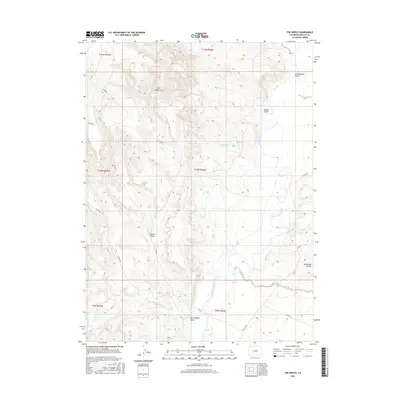
2016 Map of The Nipple
USGS Topo · Published 2016About this map
The Nipple rises as the central topographic landmark in this high-desert portion of Moffat County, overlooking a network of deep drainages and intermittent water sources. The Little Snake River meanders through the eastern half of the map, providing a vital riparian corridor in an otherwise arid landscape defined by features like Nipple Gulch and Spence Gulch. This 2016 survey illustrates the modern configuration of rural county roads, such as Co RD 66 and Co RD 160, which navigate the complex elevation changes around Red Wash Butte. The presence of the Nate Spring Reservoir and labels for Red Wash and South Nipple Gulch highlight the critical role of water management and natural drainage in this Colorado rangeland, where the Public Land Survey System grid continues to organize the open territory.
Find a feature on this map
22 named features on this map. Tap any name to fly to it.
Don’t see what you’re looking for? This feature index may not catch every label — zoom into the map to look around manually.
Map Details
Editions of this 2016 The Nipple Map
This is the sole edition of this map. No revisions or reprints were ever made.
Other maps of this area

1954 · Vernal
USGS Topo · 1:250,000

1958 · Vernal
USGS Topo · 1:250,000

1958 · Maybell
USGS Topo · 1:62,500

1960 · Vernal
USGS Topo · 1:250,000

1960 · Lone Mountain
USGS Topo · 1:62,500

1969 · Reservoir Draw
USGS Topo · 1:24,000
1969 · The Nipple SE
USGS Topo · 1:24,000

1969 · The Nipple
USGS Topo · 1:24,000
1969 · The Nipple NE
USGS Topo · 1:24,000

1969 · Powder Wash
USGS Topo · 1:24,000