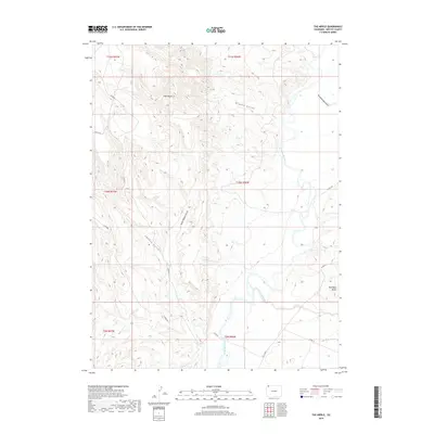
2019 Map of The Nipple
USGS Topo · Published 2019About this map
The Little Snake River meanders through the eastern section of this Moffat County terrain, defining a drainage system that includes Greasewood Gulch and Red Wash. The landscape is characterized by its prominent topographic formations, most notably the high point known as The Nipple, which overlooks a series of dissecting drainages like Nipple Gulch and South Nipple Gulch. In the southeastern corner, Red Wash Butte stands as a distinct landmark near the intersection of various rural routes. While largely an area of open rangeland and intricate geological features, a network of county roads, including Co RD 66 and Co RD 160, provides access across the various townships and ranges that structure this part of Colorado.
Find a feature on this map
21 named features on this map. Tap any name to fly to it.
Don’t see what you’re looking for? This feature index may not catch every label — zoom into the map to look around manually.
Map Details
Editions of this 2019 The Nipple Map
This is the sole edition of this map. No revisions or reprints were ever made.
Other maps of this area

1954 · Vernal
USGS Topo · 1:250,000

1958 · Vernal
USGS Topo · 1:250,000

1958 · Maybell
USGS Topo · 1:62,500

1960 · Vernal
USGS Topo · 1:250,000

1960 · Lone Mountain
USGS Topo · 1:62,500

1969 · Reservoir Draw
USGS Topo · 1:24,000
1969 · The Nipple SE
USGS Topo · 1:24,000

1969 · The Nipple
USGS Topo · 1:24,000
1969 · The Nipple NE
USGS Topo · 1:24,000

1969 · Powder Wash
USGS Topo · 1:24,000