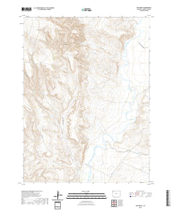
2022 Map of The Nipple
USGS Topo · Published 2022About this map
The Little Snake River meanders across this high-desert landscape in northern Moffat County, carving a wide valley floor between the drainages of the t11n r96w and t10n r96w townships. Rising prominently in the northwest is The Nipple, a distinctive landmark that anchors a complex network of dry watercourses including Nipple Gulch, South Nipple Gulch, and Spence Gulch. This modern survey reveals a largely uninhabited territory defined by topographical extremes, where the elevation drops sharply from the western ridges toward the alluvial plains of the river. Human presence is limited to a sparse network of county roads like Co Rd 66 and Co Rd 160, which facilitate movement through a region dominated by ranching interests and public land management. Further south, the terrain levels out as Red Wash approaches the river, illustrating the seasonal drainage patterns critical to this arid environment.
Find a feature on this map
19 named features on this map. Tap any name to fly to it.
Don’t see what you’re looking for? This feature index may not catch every label — zoom into the map to look around manually.
Map Details
Editions of this 2022 The Nipple Map
This is the sole edition of this map. No revisions or reprints were ever made.
Other maps of this area

1954 · Vernal
USGS Topo · 1:250,000

1958 · Vernal
USGS Topo · 1:250,000

1958 · Maybell
USGS Topo · 1:62,500

1960 · Vernal
USGS Topo · 1:250,000

1960 · Lone Mountain
USGS Topo · 1:62,500

1969 · Reservoir Draw
USGS Topo · 1:24,000
1969 · The Nipple SE
USGS Topo · 1:24,000

1969 · The Nipple
USGS Topo · 1:24,000
1969 · The Nipple NE
USGS Topo · 1:24,000

1969 · Powder Wash
USGS Topo · 1:24,000