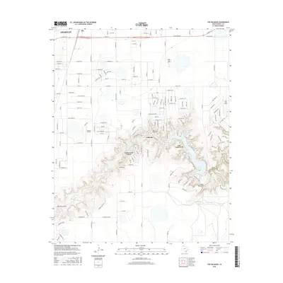
2016 Map of The Palisades
USGS Topo · Published 2016About this map
Lake Tanglewood and the winding course of the Prairie Dog Town Fork Red River anchor this landscape south of Amarillo. The terrain transitions from the developed streets of Zita in the north to the dramatic breaks of the Palo Duro Canyon system in the south. Residential expansion is evident in the cluster of roads around Palisades and the private community surrounding the lake, where a dense network of local drives like Dolphin Trl and Tangle Aire Dr navigate the steep topography. Aviation is represented by both Blue Sky Airfield and River Falls Airport, serving the local region. Geological landmarks are prominent throughout the draws, including the Devils Kitchen and Timbercreek Canyon, highlighting the erosion-carved environment that defines this portion of the Texas Panhandle. Modern transportation infrastructure, such as Loop 335 and Claude Hwy, provides the primary links between these canyon communities and the larger urban center to the north.
Find a feature on this map
87 named features on this map. Tap any name to fly to it.
Don’t see what you’re looking for? This feature index may not catch every label — zoom into the map to look around manually.
Map Details
Editions of this 2016 The Palisades Map
This is the sole edition of this map. No revisions or reprints were ever made.
Other maps of this area

1954 · Amarillo
USGS Topo · 1:250,000

1954 · Plainview
USGS Topo · 1:250,000

1956 · Fortress Cliff
USGS Topo · 1:24,000

1956 · Amarillo East
USGS Topo · 1:24,000

1956 · Thomas Ranch
USGS Topo · 1:24,000

1956 · Pullman
USGS Topo · 1:24,000

1958 · Amarillo
USGS Topo · 1:250,000

1958 · Plainview
USGS Topo · 1:250,000

1960 · Canyon
USGS Topo · 1:62,500

1960 · The Palisades
USGS Topo · 1:24,000