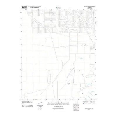
2010 Map of The Volcanoes
USGS Topo · Published 2010About this map
The volcanic landscape of the Albuquerque West Mesa is defined by the prominent peaks of The Volcanoes, including Vulcan, Bond, and Butte. This 2010 survey illustrates the stark contrast between the preserved geological features and the encroaching suburban grid of Bernalillo County. To the north, a dense network of residential streets such as Southern Blvd SW and 10th Ave SW pushes against the open high desert, while the Double Eagle II Airport stands as a major regional landmark. The terrain is deeply incised by a series of drainage systems, including the Arroyo de las Calabacillas and several forks of the San Antonio and Rinconado arroyos. Historical land usage is represented by the Black Ranch, situated near the eastern edge of the survey where the plateau begins its descent toward the Rio Grande valley.
Find a feature on this map
60 named features on this map. Tap any name to fly to it.
Don’t see what you’re looking for? This feature index may not catch every label — zoom into the map to look around manually.
Map Details
Editions of this 2010 The Volcanoes Map
This is the sole edition of this map. No revisions or reprints were ever made.
Other maps of this area

1888 · Bernalillo
USGS Topo · 1:125,000

1889 · Albuquerque
USGS Topo · 1:125,000

1893 · Albuquerque
USGS Topo · 1:125,000

1934 · West Albuquerque
USGS Topo · 1:24,000

1934 · Griegos
USGS Topo · 1:24,000

1938 · Albuquerque
USGS Topo · 1:62,500

1954 · Volcano Ranch
USGS Topo · 1:24,000

1954 · Loma Machete
USGS Topo · 1:24,000

1954 · Sky Village
USGS Topo · 1:24,000
1954 · Sky Village SE
USGS Topo · 1:24,000