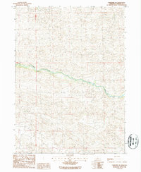
1986 Map of Thedford SW
USGS Topo · Published 1987About this map
The Dismal River carves a winding path across this portion of Thomas County, defining the central geography of the Sandhills landscape in the mid-1980s. This specific region is characterized by sparse human infrastructure, with the Paxton Ranch serving as a primary named landmark of the local ranching economy. The map illustrates the complex topography of the surrounding dunes and depressions, which dictated the placement of unimproved roads and grazing boundaries. Beyond the river corridor, the landscape is marked by township lines such as T22N and T21N, indicating the fundamental land division system that governed this interior section of Nebraska.
Find a feature on this map
4 named features on this map. Tap any name to fly to it.
Don’t see what you’re looking for? This feature index may not catch every label — zoom into the map to look around manually.
Map Details
Editions of this 1986 Thedford SW Map
This is the sole edition of this map. No revisions or reprints were ever made.
Other maps of this area

1948 · Thedford
USGS Topo · 1:62,500

1949 · Cody Lake
USGS Topo · 1:62,500

1950 · Thedford
USGS Topo · 1:62,500

1950 · Shimmins Lake
USGS Topo · 1:62,500

1951 · Tryon
USGS Topo · 1:62,500

1951 · Cody Lake
USGS Topo · 1:62,500

1954 · North Platte
USGS Topo · 1:250,000

1956 · North Platte
USGS Topo · 1:250,000

1957 · North Platte
USGS Topo · 1:250,000

1967 · North Platte
USGS Topo · 1:250,000