
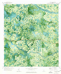
1971 Map of Thelma
USGS Topo · Published 1976About this map
The Georgia Southern and Florida railroad cuts a straight east-west path through this landscape, connecting the small settlements of Fruitland and Thelma. The terrain is dominated by a complex network of wetlands and "bays," including Stalvey Bay and Briery Bay, characteristic of the Georgia flatwoods. The winding course of Suwannoochee Creek serves as a primary drainage feature, though its shifting nature is noted by an indefinite boundary label. For local history, the map preserves specific crossing points like Starling Ford and New Ford, alongside family-named landmarks such as Wilkerson Lake and Indian Hammock. This orthophotomap provides an uncommon visual record of vegetation patterns and surface water in the early 1970s, showing the specific way human infrastructure like the rail line and a Jeep Trail navigated the saturated environments of the Clinch and Echols County border.
Find a feature on this map
28 named features on this map. Tap any name to fly to it.
Don’t see what you’re looking for? This feature index may not catch every label — zoom into the map to look around manually.
Map Details
Editions of this 1971 Thelma Map
This is the sole edition of this map. No revisions or reprints were ever made.
Other maps of this area

1954 · Valdosta
USGS Topo · 1:250,000

1958 · Valdosta
USGS Topo · 1:250,000

1959 · Valdosta
USGS Topo · 1:250,000

1968 · Midway
USGS Topo · 1:24,000

1968 · Needmore
USGS Topo · 1:24,000

1968 · Headlight
USGS Topo · 1:24,000

1971 · Du Pont
USGS Topo · 1:24,000

1971 · Stockton
USGS Topo · 1:24,000

1971 · Tarver
USGS Topo · 1:24,000
1971 · Pineland
USGS Topo · 1:24,000