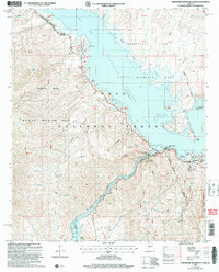
2004 Map of Theodore Roosevelt Dam
USGS Topo · Published 2007About this map
Theodore Roosevelt Dam stands as the engineering centerpiece of this central Arizona landscape, where the confluence of Tonto Creek and Salt River is managed for water storage. The 2004 revision reveals the extensive infrastructure supporting the region's dual identity as a critical utility hub and a primary recreation destination. The settlement of Roosevelt serves as a localized center, flanked by the Tonto Basin Ranger Station and a Sheriff's Substation. Significant portions of the territory are designated as protected lands, including the Tonto National Forest and the Three Bar State Wildlife Area. Geographers can trace the path of the Arizona Trail as it winds through the high ground of Vineyard Mountain and past Inspiration Point. Shoreline features like Bermuda Flat, Cholla Bay, and Roosevelt Marina illustrate the development of Roosevelt Lake for public use, while downstream, the waters of Apache Lake begin to form behind the spillway.
Find a feature on this map
60 named features on this map. Tap any name to fly to it.
Don’t see what you’re looking for? This feature index may not catch every label — zoom into the map to look around manually.
Map Details
Editions of this 2004 Theodore Roosevelt Dam Map
This is the sole edition of this map. No revisions or reprints were ever made.
Other maps of this area

1907 · Roosevelt
USGS Topo · 1:125,000

1909 · Four Peaks
USGS Topo · 1:125,000

1912 · Roosevelt
USGS Topo · 1:125,000

1954 · Mesa
USGS Topo · 1:250,000

1957 · Mesa
USGS Topo · 1:250,000

1958 · Mesa
USGS Topo · 1:250,000

1960 · Mesa
USGS Topo · 1:250,000

1964 · Mesa
USGS Topo · 1:250,000
1964 · Armer Mountain
USGS Topo · 1:24,000
1964 · Greenback Creek
USGS Topo · 1:24,000