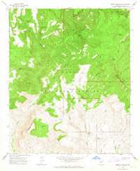
1964 Map of Armer Mountain
USGS Topo · Published 1965About this map
Sierra Ancha dominates this mid-1960s topographic study, revealing a landscape defined by significant elevation changes and seasonal water sources. The map provides a detailed view of the rugged corridor between Armer Mountain and Dutchwoman Butte, where human presence is marked by isolated outposts like Boyer Cabin and Tucker Box. Several archaeological sites, noted simply as Ruins, are scattered through Armer Gulch and near Cellar Creek, indicating a long history of habitation in these canyons. Water management is central to the area's utility, with numerous named tanks such as Upper Thompson Mesa Tank and Whiskey Tank supporting life in the high desert. Primitive transportation routes, including a complex of Jeep Trails and footpaths, navigate the steep terrain of Boyer Ridge and lead toward prominent summits like Tanner Peak. This survey documents the area as part of the Tonto National Forest prior to further modern development.
Find a feature on this map
39 named features on this map. Tap any name to fly to it.
Don’t see what you’re looking for? This feature index may not catch every label — zoom into the map to look around manually.
Map Details
Editions of this 1964 Armer Mountain Map
3 editions found
Other maps of this area

1907 · Roosevelt
USGS Topo · 1:125,000

1909 · Four Peaks
USGS Topo · 1:125,000

1912 · Roosevelt
USGS Topo · 1:125,000

1922 · Chrysotile
USGS Topo · 1:125,000

1949 · McFadden Peak
USGS Topo · 1:62,500

1949 · Rockinstraw Mtn
USGS Topo · 1:62,500

1950 · Rockinstraw Mtn
USGS Topo · 1:62,500

1950 · McFadden Peak
USGS Topo · 1:62,500

1954 · Mesa
USGS Topo · 1:250,000

1957 · Mesa
USGS Topo · 1:250,000