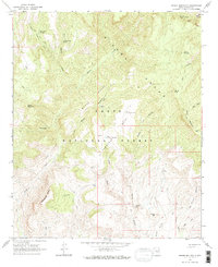
1964 Map of Armer Mountain
USGS Topo · Published 1973About this map
Sierra Ancha dominates this portion of the Tonto National Forest, where steep canyons and high ridges define the central Arizona landscape. Remote outposts and water management systems characterize the area, visible through features like the Boyer Cabin near Boyer Ridge and a series of high-altitude reservoirs including Upper Thompson Mesa Tank and Lower Thompson Mesa Tank. The topography is punctuated by prominent landmarks such as Tanner Peak, Armer Mountain, and Dutchwoman Butte. Natural water features like Salome Creek wind through the terrain, most notably at the dramatic narrow passage known as The Jug. Evidence of past habitation or temporary shelters is scattered throughout the region, marked by several Ruins and the uniquely named Tucker Box in Armer Gulch, illustrating the sparse but persistent human presence in these mountains during the early 1960s.
Find a feature on this map
40 named features on this map. Tap any name to fly to it.
Don’t see what you’re looking for? This feature index may not catch every label — zoom into the map to look around manually.
Map Details
Editions of this 1964 Armer Mountain Map
3 editions found
Other maps of this area

1907 · Roosevelt
USGS Topo · 1:125,000

1909 · Four Peaks
USGS Topo · 1:125,000

1912 · Roosevelt
USGS Topo · 1:125,000

1922 · Chrysotile
USGS Topo · 1:125,000

1949 · McFadden Peak
USGS Topo · 1:62,500

1949 · Rockinstraw Mtn
USGS Topo · 1:62,500

1950 · Rockinstraw Mtn
USGS Topo · 1:62,500

1950 · McFadden Peak
USGS Topo · 1:62,500

1954 · Mesa
USGS Topo · 1:250,000

1957 · Mesa
USGS Topo · 1:250,000