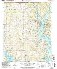
2004 Map of Theodosia
USGS Topo · Published 2006About this map
Bull Shoals Lake dominates the central and eastern portions of this Ozark landscape, where the White River and North Fork meet at the Missouri-Arkansas border. The settlement of Theodosia sits along the northern shores, serving as a focal point for the region alongside smaller communities like Sundown and Dugginsville. This survey preserves the locations of vital community landmarks, including True Hope Ch, Shiloh Ch, and several family burial grounds such as Hicks Cem and Lutie Cem. Beyond the developed areas, the terrain is characterized by numerous hollows and balds within the Mark Twain National Forest, such as Peacock Bald and McVey Bald. The map also captures infrastructure like the Theodosia Hills Landing Strip and the Public Use Area, reflecting the area's development as a destination for recreation and rural living amidst the complex fingers of the reservoir.
Find a feature on this map
50 named features on this map. Tap any name to fly to it.
Don’t see what you’re looking for? This feature index may not catch every label — zoom into the map to look around manually.
Map Details
Editions of this 2004 Theodosia Map
This is the sole edition of this map. No revisions or reprints were ever made.
Other maps of this area

1893 · Yellville
USGS Topo · 1:125,000

1903 · Yellville
USGS Topo · 1:125,000

1905 · Yellville
USGS Topo · 1:125,000

1929 · Yellville
USGS Topo · 1:125,000

1936 · Thornfield
USGS Topo · 1:48,000

1943 · Protem
USGS Topo · 1:62,500

1943 · Thornfield
USGS Topo · 1:62,500

1945 · Harrison
USGS Topo · 1:250,000

1945 · Thornfield
USGS Topo · 1:62,500

1949 · Harrison
USGS Topo · 1:250,000