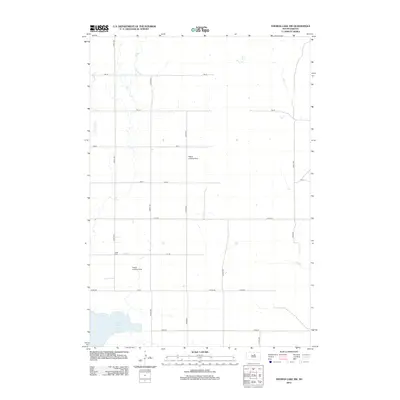
2012 Map of Thomas Lake NW
USGS Topo · Published 2012About this map
Stone Lake anchors the southern reaches of this Potter County landscape, where the prairie is defined by a precise grid of section-line roads. The meandering path of Okobojo Cr cuts through the northwest, providing a natural contrast to the geometric layout of 321st Ave and 170th St. This area exemplifies the modern agricultural structure of South Dakota, where small-scale aviation markers like Hobus Landing Strip and Fischer Landing Strip suggest the vast distances managed by local landholders. For those researching family history in the region, the Copp Cem stands as a significant landmark along the road network near the center of the sheet.
Find a feature on this map
21 named features on this map. Tap any name to fly to it.
Don’t see what you’re looking for? This feature index may not catch every label — zoom into the map to look around manually.
Map Details
Editions of this 2012 Thomas Lake NW Map
This is the sole edition of this map. No revisions or reprints were ever made.
Other maps of this area

1953 · Huron
USGS Topo · 1:250,000

1954 · Aberdeen
USGS Topo · 1:250,000

1954 · Huron
USGS Topo · 1:250,000

1956 · Aberdeen
USGS Topo · 1:250,000

1974 · Gettysburg Municipal Airport SE
USGS Topo · 1:24,000
1974 · Gettysburg Muni. Airport NE
USGS Topo · 1:24,000
1978 · Bald Hills
USGS Topo · 1:24,000
1978 · Thomas Lake
USGS Topo · 1:24,000
1978 · Thomas Lake SW
USGS Topo · 1:24,000
1978 · Seneca SW
USGS Topo · 1:24,000