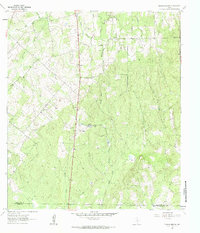
1961 Map of Thomas Springs
USGS Topo · Published 1985About this map
The rolling ranchlands along the Guadalupe Co Wilson Co line are defined by a network of seasonal streams and traditional community centers in the early 1960s. Thomas Springs and Kings Hill anchor the central topography, while Ecleto Creek and its tributary East Fork Ecleto Creek drain the southern portion of the quadrangle. The map reveals the social fabric of the rural landscape through landmarks such as Zion Hill Ch, the adjacent Zion Hill Cem, and Jakes Colony Ch. A specific interest for local historians and land researchers is the depiction of Weinert Ranch and the fine red dashed lines indicating selected fence lines, which provide a rare look at the established property boundaries of the era. This document is a detailed study of the transitional drainage basin between Elm Creek and the Ecleto system, showing a place where traditional agricultural life continued alongside emerging infrastructure like a prominent Radio Tower and a cross-country Pipeline.
Find a feature on this map
19 named features on this map. Tap any name to fly to it.
Don’t see what you’re looking for? This feature index may not catch every label — zoom into the map to look around manually.
Map Details
Editions of this 1961 Thomas Springs Map
3 editions found
Other maps of this area

1911 · San Marcos
USGS Topo · 1:125,000

1919 · San Marcos
USGS Topo · 1:125,000

1920 · Smiley
USGS Topo · 1:125,000

1924 · New Braunfels No 4
USGS Topo · 1:48,000

1924 · San Marcos 3-c
USGS Topo · 1:48,000

1924 · San Marcos 3-d
USGS Topo · 1:48,000

1927 · New Braunfels
USGS Topo · 1:62,500

1930 · Seguin
USGS Topo · 1:62,500

1942 · Dewville
USGS Topo · 1:62,500

1953 · Seguin
USGS Topo · 1:250,000