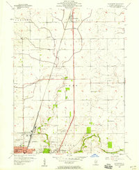
1957 Map of Thomasboro
USGS Topo · Published 1959About this map
Thomasboro sits at the northern edge of this agricultural landscape in central Illinois, anchored by the north-south corridor of the Illinois Central railroad. The map documents the rural-to-urban transition as the northern fringes of Champaign and Urbana begin to expand, with Wilbur Heights and Augerville appearing as early developments. Local infrastructure of the late 1950s is highly detailed, featuring the Illini Airport and a nearby Drive-in Theater, reflecting the era's mid-century automotive and aviation culture.
Find a feature on this map
32 named features on this map. Tap any name to fly to it.
Don’t see what you’re looking for? This feature index may not catch every label — zoom into the map to look around manually.
Map Details
Editions of this 1957 Thomasboro Map
This is the sole edition of this map. No revisions or reprints were ever made.
Other maps of this area

1906 · Urbana
USGS Topo · 1:62,500

1907 · Mahomet
USGS Topo · 1:62,500

1924 · Paxton
USGS Topo · 1:62,500

1927 · Paxton
USGS Topo · 1:62,500

1928 · Gibson City
USGS Topo · 1:62,500

1949 · Paxton
USGS Topo · 1:62,500

1957 · Urbana
USGS Topo · 1:62,500

1957 · Paxton
USGS Topo · 1:62,500

1957 · Gibson City
USGS Topo · 1:62,500

1957 · Urbana
USGS Topo · 1:24,000