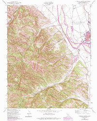
1949 Map of Thompson Canyon
USGS Topo · Published 1984About this map
King City sits at the junction of the Salinas River valley and the rugged coastal ranges, serving as a vital agricultural and transit hub along the Southern Pacific railroad line. This 1949 survey, with revisions into the early 1980s, illustrates the town's expansion toward San Lorenzo County Park and the development of local infrastructure like a sewage disposal plant and multiple pumping stations. Beyond the urban core, the landscape is defined by a series of dramatic land grants and drainages, including the Posa de los Ositos and San Bernabe areas.
Find a feature on this map
22 named features on this map. Tap any name to fly to it.
Don’t see what you’re looking for? This feature index may not catch every label — zoom into the map to look around manually.
Map Details
Editions of this 1949 Thompson Canyon Map
4 editions found
Other maps of this area

1912 · Metz
USGS Topo · 1:31,680

1915 · Soledad
USGS Topo · 1:62,500

1919 · King City
USGS Topo · 1:62,500

1919 · Junipero Serra
USGS Topo · 1:62,500

1921 · Metz
USGS Topo · 1:62,500

1939 · King City
USGS Topo · 1:62,500

1940 · Metz
USGS Topo · 1:62,500

1940 · Soledad
USGS Topo · 1:62,500

1941 · Junipero Serra
USGS Topo · 1:62,500

1947 · Metz
USGS Topo · 1:62,500