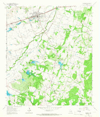
1964 Map of Thorndale
USGS Topo · Published 1966About this map
Thorndale anchors the northern portion of this landscape, situated along the Missouri Pacific railroad line near the junction of Milam and Williamson counties. The settlement pattern shows a concentration of local infrastructure such as Jackson Lake, the Athletic Field, and St John Ch, while the surrounding terrain is defined by a series of water management sites. Numerous numbered spillway locations, including Site No 20 and Site No 24, indicate a developed system of flood control and water storage across branches like Brushy Creek and Schoolhouse Branch.
Find a feature on this map
35 named features on this map. Tap any name to fly to it.
Don’t see what you’re looking for? This feature index may not catch every label — zoom into the map to look around manually.
Map Details
Editions of this 1964 Thorndale Map
2 editions found
Other maps of this area

1885 · Taylor
USGS Topo · 1:125,000

1885 · Bastrop
USGS Topo · 1:125,000

1887 · Taylor
USGS Topo · 1:125,000

1893 · Bastrop
USGS Topo · 1:125,000

1894 · Taylor
USGS Topo · 1:125,000

1904 · Bastrop
USGS Topo · 1:125,000

1948 · Elgin
USGS Topo · 1:62,500

1948 · Lexington
USGS Topo · 1:62,500

1950 · Lexington
USGS Topo · 1:62,500

1950 · Elgin
USGS Topo · 1:62,500