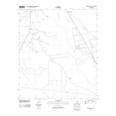
2010 Map of Thorson Gully
USGS Topo · Published 2010About this map
The New Batson Oil Field dominates the northwestern portion of this landscape, reflecting the region's long-standing connection to the petroleum industry. The settlement of Batson serves as a local hub near several family-named landmarks and historical sites, including the Guedry Cemetery and the expanse of Batson Prairie. The terrain is defined by a complex network of waterways, where Pine Island Bayou meanders through the eastern section, joined by smaller drainages such as Thorson Gully, Mayhaw Creek, and Batiste Creek. To the south, the settlement of Strain sits near The Forks, while the open reaches of Sams Prairie and the curiously named Rattlesnake Bead highlight the traditional coastal prairie character of Hardin County. This 2010 survey provides a modern snapshot of rural land use, from energy extraction to the preserve of natural bayous and sloughs.
Find a feature on this map
29 named features on this map. Tap any name to fly to it.
Don’t see what you’re looking for? This feature index may not catch every label — zoom into the map to look around manually.
Map Details
Editions of this 2010 Thorson Gully Map
This is the sole edition of this map. No revisions or reprints were ever made.
Other maps of this area

1943 · Liberty
USGS Topo · 1:125,000

1954 · Beaumont
USGS Topo · 1:250,000

1955 · Daisetta
USGS Topo · 1:62,500

1955 · Saratoga
USGS Topo · 1:62,500

1955 · Kountze
USGS Topo · 1:62,500

1955 · Sour Lake
USGS Topo · 1:62,500

1957 · Beaumont
USGS Topo · 1:250,000

1984 · Beaumont
USGS Topo · 1:250,000
1984 · Nome
USGS Topo · 1:24,000

1984 · Sour Lake
USGS Topo · 1:24,000