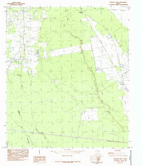
1984 Map of Thorson Gully
USGS Topo · Published 1985About this map
Big Thicket National Preserve dominates the northeastern landscape of this mid-1980s Hardin County survey, showcasing the dense bottomland forests and wetlands characteristic of the region. The map captures the small community of Batson in the northwest, situated near the headwaters of Thorson Gully and Gum Gully. The local economy is visibly tied to the land, with an Oil + Gas Field mapped in the southwest near the Hardin Co Liberty Co boundary.
Find a feature on this map
16 named features on this map. Tap any name to fly to it.
Don’t see what you’re looking for? This feature index may not catch every label — zoom into the map to look around manually.
Map Details
Editions of this 1984 Thorson Gully Map
This is the sole edition of this map. No revisions or reprints were ever made.
Other maps of this area

1943 · Liberty
USGS Topo · 1:125,000

1954 · Beaumont
USGS Topo · 1:250,000

1955 · Daisetta
USGS Topo · 1:62,500

1955 · Saratoga
USGS Topo · 1:62,500

1955 · Kountze
USGS Topo · 1:62,500

1955 · Sour Lake
USGS Topo · 1:62,500

1957 · Beaumont
USGS Topo · 1:250,000

1984 · Beaumont
USGS Topo · 1:250,000
1984 · Nome
USGS Topo · 1:24,000

1984 · Sour Lake
USGS Topo · 1:24,000