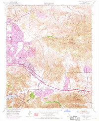
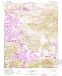
1950 Map of Thousand Oaks
USGS Topo · Published 1968About this map
The Conejo Valley serves as the focal point for this mid-century survey, capturing the early expansion of Thousand Oaks before its rapid suburban densification. The landscape is defined by the transition from the Simi Hills down through several prominent canyons, including Lindero Canyon and Skeleton Canyon. While the Ventura Freeway corridor already marks the valley floor, the surrounding terrain still holds agricultural and ranching features such as Lang Ranch and the Norwegian Grade. To the south, the Santa Monica Mountains rise above Lake Sherwood and Potrero Creek, illustrating the geographical barriers that shaped local settlement. Smaller hubs like Greenwich Village and Triunfo Corner appear alongside family landmarks such as the Olson Cem, providing a window into the area's rural roots and early educational infrastructure at Conejo Sch.
Find a feature on this map
37 named features on this map. Tap any name to fly to it.
Don’t see what you’re looking for? This feature index may not catch every label — zoom into the map to look around manually.
Map Details
Editions of this 1950 Thousand Oaks Map
5 editions found
Other maps of this area

1900 · Triunfo Pass
USGS Topo · 1:62,500

1900 · Piru
USGS Topo · 1:62,500

1903 · Calabasas
USGS Topo · 1:62,500

1903 · Camulos
USGS Topo · 1:125,000

1903 · Santa Susana
USGS Topo · 1:62,500

1921 · Piru
USGS Topo · 1:62,500

1921 · Triunfo Pass
USGS Topo · 1:62,500

1929 · Vejor
USGS Topo · 1:24,000

1932 · Seminole
USGS Topo · 1:24,000

1932 · Russell Valley
USGS Topo · 1:24,000