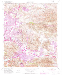
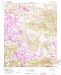
1950 Map of Thousand Oaks
USGS Topo · Published 1982About this map
Thousand Oaks and the surrounding El Conejo region appear here during a period of significant suburban expansion, as indicated by the purple-tinted photorevisions added in 1981 to the original 1950 topography. This layer of development is superimposed over an older ranching and agricultural landscape, where features like Lang Ranch and Tang Ranch still defined large portions of the terrain. The Ventura Freeway serves as the primary spine of this growth, connecting established points like Triunfo Corner and Malibu Junction to new residential areas like Greenwich Village.
Find a feature on this map
39 named features on this map. Tap any name to fly to it.
Don’t see what you’re looking for? This feature index may not catch every label — zoom into the map to look around manually.
Map Details
Editions of this 1950 Thousand Oaks Map
5 editions found
Other maps of this area

1900 · Triunfo Pass
USGS Topo · 1:62,500

1900 · Piru
USGS Topo · 1:62,500

1903 · Calabasas
USGS Topo · 1:62,500

1903 · Camulos
USGS Topo · 1:125,000

1903 · Santa Susana
USGS Topo · 1:62,500

1921 · Piru
USGS Topo · 1:62,500

1921 · Triunfo Pass
USGS Topo · 1:62,500

1929 · Vejor
USGS Topo · 1:24,000

1932 · Seminole
USGS Topo · 1:24,000

1932 · Russell Valley
USGS Topo · 1:24,000