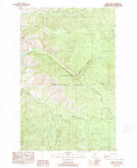
1989 Map of Thrapp Mtn
USGS Topo · Published 1989About this map
The Red Shirt Mine and several surrounding prospects stand at the western edge of this rugged highland landscape, marking the extractive history of the Methow Valley area in the late 1980s. This territory is dominated by the Okanogan National Forest, where steep drainages like Finley Canyon and Benson Creek carve through the Okanogan Highlands. The elevation is defined by a series of prominent peaks and ridges, including Thrapp Mtn, Pole Pick Mtn, and the high point of Mt Leecher in the southwest. A network of primitive trails and unimproved roads connects isolated water sources such as Wenner Lakes to the more significant watercourses like Frazer Creek and the South Fork Benson Creek. The map provides a detailed view of the drainage patterns and topography used by foresters and miners before modern developments altered these backcountry routes.
Find a feature on this map
22 named features on this map. Tap any name to fly to it.
Don’t see what you’re looking for? This feature index may not catch every label — zoom into the map to look around manually.
Map Details
Editions of this 1989 Thrapp Mtn Map
2 editions found
Other maps of this area

1899 · Methow
USGS Topo · 1:125,000

1901 · Methow
USGS Topo · 1:125,000

1905 · Okanogan
USGS Topo · 1:125,000

1954 · Okanogan
USGS Topo · 1:250,000

1955 · Concrete
USGS Topo · 1:250,000

1956 · Loup Loup
USGS Topo · 1:62,500

1957 · Brewster
USGS Topo · 1:62,500

1958 · Concrete
USGS Topo · 1:250,000

1958 · Okanogan
USGS Topo · 1:250,000

1962 · Concrete
USGS Topo · 1:250,000