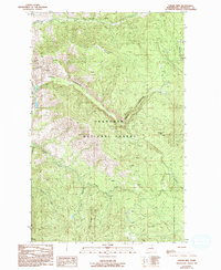
1989 Map of Thrapp Mtn
USGS Topo · Published 1993About this map
Okanogan National Forest land defines this terrain, which was documented during a series of field checks and aerial surveys in the late 1980s. The landscape is marked by substantial elevation changes, ranging from the heights of Thrapp Mtn and Pole Pick Mtn down through the steep descent of Finley Canyon. Water resources are central to the geography here, with Frazer Creek in the north and the South Fork Benson Creek flowing near Jay Ridge. Evidence of resource extraction and prospecting is visible in the northwest, specifically noted at the Red Shirt Mine and several prospect sites nearby. This provisional survey provides a precise record of the drainage patterns and peaks within Okanogan County, illustrating the high-country environment before the turn of the century.
Find a feature on this map
20 named features on this map. Tap any name to fly to it.
Don’t see what you’re looking for? This feature index may not catch every label — zoom into the map to look around manually.
Map Details
Editions of this 1989 Thrapp Mtn Map
2 editions found
Other maps of this area

1899 · Methow
USGS Topo · 1:125,000

1901 · Methow
USGS Topo · 1:125,000

1905 · Okanogan
USGS Topo · 1:125,000

1954 · Okanogan
USGS Topo · 1:250,000

1955 · Concrete
USGS Topo · 1:250,000

1956 · Loup Loup
USGS Topo · 1:62,500

1957 · Brewster
USGS Topo · 1:62,500

1958 · Concrete
USGS Topo · 1:250,000

1958 · Okanogan
USGS Topo · 1:250,000

1962 · Concrete
USGS Topo · 1:250,000