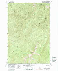
1966 Map of Three Prong Mountain
USGS Topo · Published 1987About this map
Warm Springs Bar and Lynx Meadows mark the few habitable openings in this high-elevation Idaho backcountry, where the Nezperce National Forest and Bitterroot National Forest meet. Surveyed in the mid-1960s, the terrain is defined by a series of prominent divides, including Parachute Ridge, Warm Springs Ridge, and Three Prong Ridge. The drainage system is particularly complex, with Running Creek and Bargamin Creek carving deep basins that fall away from landmarks like Eagle Point and the aptly named The Drop-off. Access during this era was limited to an extensive network of footpaths, including the Pack Trail and Patrol Trail, which served foresters and early wilderness travelers. The map also delineates the Selway Bitterroot Wilderness boundary, capturing the region's character as a strictly preserved natural corridor.
Find a feature on this map
26 named features on this map. Tap any name to fly to it.
Don’t see what you’re looking for? This feature index may not catch every label — zoom into the map to look around manually.
Map Details
Editions of this 1966 Three Prong Mountain Map
2 editions found
Other maps of this area

1956 · Elk City
USGS Topo · 1:250,000

1960 · Elk City
USGS Topo · 1:250,000

1966 · Spot Mountain
USGS Topo · 1:24,000

1966 · Green Mtn.
USGS Topo · 1:24,000

1966 · Three Prong Mountain
USGS Topo · 1:24,000
1966 · Wylies Peak
USGS Topo · 1:24,000
1966 · Gardiner Peak
USGS Topo · 1:24,000
1966 · Running Lake
USGS Topo · 1:24,000

1978 · Spread Creek Point
USGS Topo · 1:24,000

1978 · Magruder Mtn
USGS Topo · 1:24,000