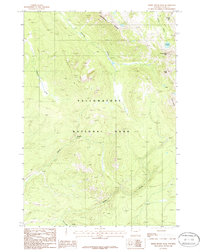
1986 Map of Three Rivers Peak
USGS Topo · Published 1986About this map
Three Rivers Peak serves as a hydrologic focal point in this 1980s landscape, where the headwaters of the Gallatin River and several significant creeks begin their descent through Yellowstone National Park. The map documents a wilderness dominated by dramatic elevations and high-altitude drainage systems, including the basin of Gallatin Lake and the long spine of Crowfoot Ridge. This area illustrates the complex topography of the park's northwestern interior, where numerous watercourses like Gneiss Creek, Grayling Creek, and Maple Creek carve through the high country. For those studying the geography of the park before modern digital mapping, these provisional surveys provide precise detail on the locations of named landmarks such as Bighorn Pass and The Crags, as well as the intricate network of trails and ridges that define this portion of the Gallatin Range.
Find a feature on this map
14 named features on this map. Tap any name to fly to it.
Don’t see what you’re looking for? This feature index may not catch every label — zoom into the map to look around manually.
Map Details
Editions of this 1986 Three Rivers Peak Map
This is the sole edition of this map. No revisions or reprints were ever made.
Other maps of this area

1885 · Gallatin
USGS Topo · 1:125,000

1885 · Gallatin
USGS Topo · 1:125,000

1901 · Gallatin
USGS Topo · 1:125,000

1908 · Gallatin
USGS Topo · 1:125,000

1911 · Gallatin
USGS Topo · 1:125,000

1955 · Ashton
USGS Topo · 1:250,000

1958 · Ashton
USGS Topo · 1:250,000

1958 · Madison Junction
USGS Topo · 1:62,500

1958 · Mount Holmes
USGS Topo · 1:62,500

1958 · West Yellowstone
USGS Topo · 1:62,500