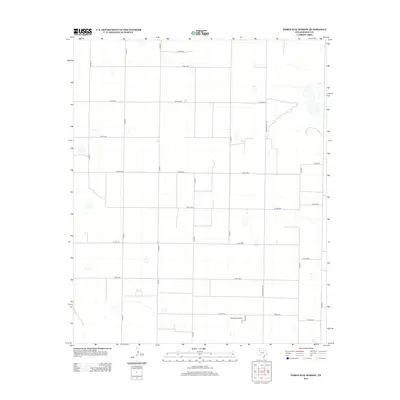
2012 Map of Three Way School
USGS Topo · Published 2012About this map
Three Way School serves as the central landmark in this high plains landscape of southern Bailey County. The area is defined by a rigid grid of agricultural roads, including north-south corridors like Co Rd-41 and Co Rd-51, which segment the flat terrain into large parcels. Scattered across the surface are numerous small depressions and basins, characteristic of the Llano Estacado's unique hydrology. Transport through the district is anchored by Ranch Road 1731, which cuts vertically through the eastern portion of the quadrangle. This 2012 survey illustrates a landscape dominated by modern industrial-scale farming, where the rural infrastructure is built entirely around the movement of agricultural goods and the localized community hub at the school site.
Find a feature on this map
23 named features on this map. Tap any name to fly to it.
Don’t see what you’re looking for? This feature index may not catch every label — zoom into the map to look around manually.
Map Details
Editions of this 2012 Three Way School Map
This is the sole edition of this map. No revisions or reprints were ever made.
Other maps of this area

1954 · Clovis
USGS Topo · 1:250,000

1954 · Brownfield
USGS Topo · 1:250,000

1957 · Arch
USGS Topo · 1:62,500

1958 · Brownfield
USGS Topo · 1:250,000

1958 · Clovis
USGS Topo · 1:250,000

1962 · Brownfield
USGS Topo · 1:250,000

1962 · Stegall
USGS Topo · 1:24,000

1962 · Baileyboro
USGS Topo · 1:24,000

1968 · Three Way School
USGS Topo · 1:24,000
1968 · Upper White Lake
USGS Topo · 1:24,000